Maps+ is a new application launched in the AppStore that extends the functionality of the native Maps application in iOS. The new application brings users a series of functions that are missing in iOS, but which for some will not prove to be so useful. The application allows us to set an alarm that sounds when we reach a location, we also have the possibility to make a log with our locations on the map but also to edit or send them on Twitter and finally we have the possibility to import locations directly from the Safari browser. Maps+ tries to extend the functionality of the Maps application, but although the basic version of the application is free, some options require purchase.
The developer has included the possibility to unlock certain functions, but the unlocking costs €2.39 and is done through in-app purchase, so you will have to buy the functions if you want them. In general, we have the Maps application, but much improved, but if the price of unlocking all options was only €0.79, then I think the application would have been more successful.
Here are all the Maps+ functions:
- Browse Google's online maps: standard, satellite, hybrid and terrain. Swipe with 3 fingers up/down on the map to change quickly between the map types.
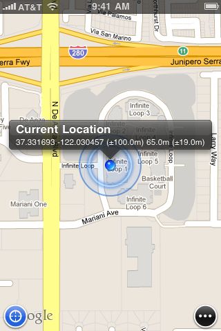
- Find out and continuously follow where you are. Tap on your current location to get more info about your fixed location: coordinates, horizontal accuracy, altitude and vertical accuracy (available on devices with GPS).
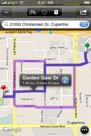
- Get online route directions with alternatives. Add transit points to your routes and get bicycling directions (US only), too.
- Record and edit GPS tracks (available on devices with GPS).
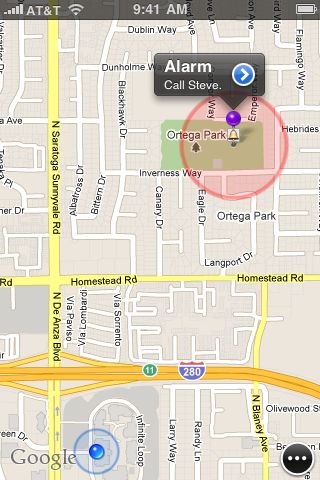
- Use location based alarms to remind yourself of tasks that are location specific (eg to get off at a train station).
- If your device supports multitasking then GPS track recording and alarm monitoring works while the app runs in the background, too. Continued use of GPS running in the background can dramatically decrease battery life.
- Find out what people tweet around you and engage with them in a conversation. Log in to Twitter to view your friends' tweets on the map.
- Add labels to your bookmarks (alarms, pins, routes, tracks).
- Export your bookmarks (alarms, pins, tracks) to GPX via mail or iTunes.
- Import bookmarks by opening a GPX file with Maps+ using Safari, Mail or any other app that supports quick look.
- Link to alarms and pins. Open these links on your device to add them to your bookmarks in Maps+. Sample link: http://mapspl.us/pin?coordinates=37.331966,122.030232&name=Apple
- Simple and clean user interface: all features can be accessed via 1 button. You can put buttons on the map for those features that you use frequently.
You can download Maps+ from the link below.

-
Maps+
Free
Description: Browse Google's maps, find out where you are, search for addresses, get directions with route alternatives, use location based alarms, record and edit GPS tracks, scan the map for tweets and export & import...