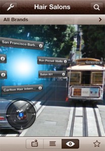
Where To? este o aplicatie pentru iPhone care implementeaza API-urile pentru realitate augmentata in ideea de a oferi utilizatorilor informatii despre punctele de interes din jurul propriei locatii. Aplicatia este disponibila in AppStore de ceva vreme, insa recet a fost actualizata si i-a fost implementat un modul 3D care afiseaza punctele de interes intr-un mod cu totul si cu totul inedit. Aplicatia foloseste si API-urile pentru OpenGL pentru a oferi utilizatorilor imagini cat mai reale despre punctele de interes disponibile.
Our solution: First, results are displayed in a real 3D world and their size and stacking order depends on the distance. Then, you can zoom in and out using the gestures already known from the map: Double-tap to zoom in, two-finger-tap to zoom out, pinch for fine grained zooming. Zooming of course affects the camera picture as well.
Acest gen de aplicatii incep sa atraga din ce in ce mai multi utilizatori deoarece ofera posibiltiatea de a vedea toate punctele de interes din jurul tau folosind camera telefonului. Sa spunem de exemplu ca esti pe o strada din Bucuresti si cauti cea mai apropiata statie de metro, ei bine deschizi aplicatia, indrepti terminalul inainte si pe ecran vei vedea afisate puncte de interes si locatia loc. Pe masura ce inaintezi aceste puncte de interes isi vor modifica pozitia pentru a te ghida inspre ele. Exista si pentru Romania o astfel de aplicatie, a participat si la concursul de aplicatii organizat de Orange insa din pacate are puncte de interes doar pentru Bucuresti.


